River
Columbia River
THERE is probably no large river in North America of which the readers know so little as the Columbia. If you will take a map of North America, or of the United States, it will aid you in considering what I now write to you.
Comparing the American coasts of the Atlantic and the Pacific you will notice a great difference of outline. The Atlantic coast is fringed with inlets, river-mouths, bays, and gulfs, while the Pacific coast is regularly and smoothly outlined.
From the San Diego (Deea-go), in the extreme south of California, to Vancouver's Island, in British Columbia, there is scarcely a good harbor or safe refuge from storm except that of San Francisco through the "Golden Gate." And even that is often difficult to enter in a storm on account of the frequency of heavy fogs.
Looking at the map you may think the mouth of the Columbia River is a good refuge from storm, but there is a heavy "bar" at the mouth which makes an entrance difficult, and sometimes impossible, to sail vessels, in stormy weather.
When I was a boy and studied geography, I was told that the name Pacific was given to this ocean because it was so quiet and free from storms. The number of vessels and lives lost along this coast during the last two years make me doubt the propriety of so naming it; but that may be owing in part to the lack of good, safe harbors, for I believe it is not subject to such terrific storms as is the Atlantic, unless it is far to the south.
"Crossing the bar" at the mouth of the Columbia is quite an event to weak-nerved and seasick passengers, with whom, however, I could not sympathize. We crossed at early dawn, and I was on the upper deck to enjoy the scene. On the northern point, on the Washington side, is Cape Disappointment, or used to be, and I felt considerable disappointment to learn that our government has changed its name to Cape Hancock, as it was a geographical landmark of my school days.
Our vessel was a propeller, that is, it had no wheels on its sides, but a large iron screw at the stern by which it was propelled or pushed ahead.
These vessels are narrower than others, and when in the trough of the tide they rock constantly even when there is no wind. We had rocked all the way from San Francisco, and in crossing the bar we had its last desperate struggle, as if the vessel wished to have one hearty shake before entering the quiet waters of the river. Everything movable had to move, and some of the seasick ones took the first exercise they had had for several days.
But this over, we were in smooth water, and the sick began to come on deck. We soon landed at Astoria, an old village founded by Astor for the Fur Company. There are some new buildings, yet the town is very small for its age. It is surrounded, except on the river side, with high sand-hills which are covered with small fir-trees.
Canning salmon appears to be the principal business of the place. While we were at the wharf, a tugboat steamed up with twelve fishing-boats, which it had gathered on the river, each having a quantity of large salmon. Hundreds of Chinamen are employed in these canneries.
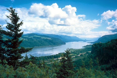
From the mouth of the Columbia to the mouth of the Willamette (accent on second syllable), the scenery is varied and pleasing. Perhaps the effect is heightened to the traveler by the sudden change from the ocean voyage.
The banks are mostly high and precipitous, often quite rocky, with frequent mountain streams forming beautiful cascades as they dash on to the river. Except on the bottomlands, which are nowhere extensive, there is no variety of timber, as there is on our Eastern Rivers. The continuous fringe of fir becomes monotonous, and detracts from the interest of the view.
When I ascended the river, the bottomlands were all overflowed, many houses being carried away. At Kalama (Ca-lam'-a), the southern terminus of the railroad to Puget Sound, the water was over the floors of cars on the highly elevated track. But the height of the flood was unusual.
All vessels, which make into the Columbia River go to Portland, which is the largest city in Oregon, about one hundred miles above Astoria, and twelve or fourteen up the Willamette.
The latter stream is rather narrow, but deep as far up as to Portland. The vessels, which run on the upper Columbia, to the Cascades, start from Portland. Leaving Portland we find fifty miles of river similar to that which we have already parsed, except that there is rather more bottom-land, and therefore a little more variety of trees. Not far above the mouth of the Willamette, on the north side of the Columbia, is Vancouver, the pleasantest-looking; place on the river. Fort Vancouver, just above the village, lies on a beautiful plat sloping south toward the river.
The hills gradually increase in height, until we reach the Cascades. This is the name both of the mountain range and of the rapids of the river.
The Cascade Mountains rise abruptly from the river's bank on the south, of Oregon side, to a height of 3000 Feet. On the north side there is a valley several miles in width in some places. At the foot of the Cascades on the north side is Castle Rock, an isolated rock, which towers up 800 feet. It was the intention of Jay Cooke, in the days of his prosperity, to place on its top a sheet of iron painted to represent the American flag. In a more open country it would be a splendid landmark. Viewing it, I thought no ambition nor curiosity could induce me to scale its steep sides to its dizzy height. I did not learn that anybody has ever ascended it. The Cascades (rapids) are six miles in length. A narrow-gauge rail-road, conveys passengers and freight this distance. The river is very narrow, sometimes looking like a small stream as we almost hang over its waters in rounding a rocky point. It is also very crooked, rushing through its rugged confines, and foaming over its rocky bed.
In this range, about forty miles from the river, in Oregon, is Mt. Hood, the highest of all the peaks in that part of the country; about 15,000 feet. It is a beautiful mount, as seen from a distance, rising with great regularity of surface, a perfect cone as seen from most directions, always covered with snow. It is a notable landmark, being plainly seen from a great distance. On the north side of the river is Mt. St. Helens. The Indians have a tradition that the Cascade Range was once entire, shutting in the waters into a large lake or sea to the east, and that Mt. Hood and St. Helens got mad and threw stones at each other, and thus broke up the mountains, forming the river channel through them. It is not difficult to imagine that great convulsions of nature have wrought such changes. A company who ascended Mt. Hood in July, 1876, reported that a crater is found at the top from which smoke still issues.
J. H. WAGGONER
COLUMBIA RIVER.
ABOVE and near the Cascades is a wonderful curiosity. The river spreads over a shallow place on which there are stumps of trees, evidently of fir, which shows that the land has been depressed, perhaps by a slide, as fir does not grow on wet bottoms. At the ordinary stage of the river these stumps are seen, being wood above the water, and petrified, or turned to stone, under the water.
Of course I could not examine these, passing on the boat, but had to trust to information received. I was told that the State Geologist of Oregon says it is the only place in the world where such a curious combination of wood and stone is found.
Above the Cascades we embark on another boat, which conveys us another fifty miles to the Dalles. This is, perhaps, the most beautiful part of the river. The rocky hills are high, and so peculiar in formation that they present an endless variety of interesting shapes to the eye. Sometimes they are perpendicular from the water's edge, and sometimes so pointed as to present a succession of turrets, reminding one of extensive ruins of castles and fortresses.
Arriving at the Dalles, we find a pleasant village, and here we take another railroad fifteen miles in length.
From this point my disappointment in the river was continuous. We always form some idea of a country when we hear or read of it, and my ideas of this part of the country were as far as possible from the truth. The Dalles are even narrower than the Cascades, the river running between banks of rock perpendicular on both sides; sometimes in one channel, sometimes dividing around rocks into two or more channels, and yet in banks mostly perpendicular. Toward the head of the Dalles are rapids or falls of ten to fifteen feet.
From the description of its rocky passes, I supposed the river was here, shut in by the mountains as at the Cascades. The hills back from the river, though high, do not present the same mountainous appearance, but resemble the rocky bluffs of a prairie country, there being no timber of any consequence in sight. Often, as we fide through the narrow valley in which the river lies, though the track is considerably elevated, the river is entirely lost to sight in its deep and narrow bed. If the reader will look on the map, he will see that the Clarke Fork, or Columbia River, rises in Montana near the head waters of the Missouri, takes a west and north-west course into British Columbia, and then stretches down the whole width of Washington Territory, gathering the waters of many streams in its long course; while the Lewis Fork, or Snake River, rises also in the borders of Montana and Wyoming, passes through Idaho, then north, forming the east line of Oregon, takes a circuit into Washington Territory, and unites with the other fork a short distance above the Oregon line. And all the waters from this vast region are compressed within such narrow bounds at the Dalles that you may look over the treeless valley, not a level plain, but scooped out from hill to hill, and there is no appearance of water presented. There is no wide break, as of a riverbed, but it is so narrow that you seem to behold every foot of the valley. And it is difficult to realize that the waters gathered from many mountains in the noble Columbia lie unseen almost at your feet.
Above the Dalles, the river scenery does not resume any of the appearance with which we have become so familiar below. There is no more timber in sight. The banks vary in height, being sometimes bold and rocky, and again low enough to give a view of the plain far back; but the steamer plows its way from sunrise to sunset, and no trees are to be seen except a few along the bank.
The land immediately along the river is mostly worthless, if not from natural sterility, from the impossibility to get water upon it. Occasionally small strips of bottomland are found and settled upon, but these are rare.
Umatilla and Wallula are the only river villages between the Dalles and the eastern boundary of Washington, and these make a better show on the map than any other way. They are set down in the desert, where it is not possible to raise anything, and of course they look dreary and forsaken. They are little villages, made necessary by the want of trade, the farming country commencing fifteen twenty, and sometimes thirty miles from the river.
This makes it hard for the farmer, as he has to team from fifteen to thirty miles over a sandy, barren or alkali desert to get his produce to the river where it is shipped to market.
Wallula is in Washington, near the line, at the mouth of Walla Walla River. Here old Fort Walla Walla was built, by the Fur Company in 1820; it was an adobe, or mud fort, and part of it is yet standing. The United States fort of the same name is about thirty miles from the river, near Walla Walla City. In justice to the country, I must say there is an excellent wheat-raising country back of this desert-lining to the river; but these two difficulties are much against the settlers; that of getting their produce to the river, and the difficult navigation of the river.
Near the foot of the Blue Mountains there is a strip, which is well adapted to fruit. And wherever the streams are available for irrigation, fruit is easily raised.
Above Wallula I was not on the river, and must therefore now take leave of the subject, as I proposed to notice only the river and the country along its banks. But I was informed by those, who had traveled much on it, that the general features of both forks are similar to those we find above the Dalles, on the main stream.
Taken altogether, it lacks the loveliness and home-like beauty of the scenery on the Hudson and the Upper Mississippi, but there is often a grandeur and nobleness which inspire the beholder with awe; and I wish I could give the reader some idea of the feelings with which I looked upon these wonderful works of the great Creator. But this I shall not attempt.
It is far beyond my power. I hope, however, that I have enabled the youthful reader to study the map of that country with additional interest and to greater profit.
J. H. WAGGONER.
FROST-WORK.
FOR several days in the past, the frost has been gathering and clinging to everything within its reach, presenting the most beautiful work of nature we ever witnessed. Perhaps it has pervaded the country extensively, and adorned the towns, villages and country in other States; but we think no place can look so beautiful as our own little valley among the Adirondack Mountains.
High mountain ranges surround us on every side; the river and brooks are frozen, excepting in places where the rapids are, and the snow lies upon the ground a foot deep. The frost clings to the highest peaks, where it is too cold and windy for the snow to lie, and has made its way down, enwrapping the valley below with its snowy drapery. The alders on the banks of the river; the willows and ferns by the brook; every bush and stalk lifting its head above the snow; every leaf of the evergreen, and tiny twig of the tall, stately trees, is completely covered with the sparkling frost, so thick that only the trunks of the large trees can be seen.
As we look out upon the mountains, hills, valleys, lakes, rivers, brooks, and waterfalls, so beautifully dressed in white, and glittering in the sun- light, what feelings of sublimity it awakens! How we love the beautiful and pure! How it raises our thoughts and desires above to the Author of all purity!
NETTIE HOLT.
HEDGE round thy life with prayer,
Knowing this truth,
That sin in youth
Is seed which, sown in unknown fields,
A crown of thorns in manhood yields,
Which he who sows must wear.
- Home
- A Beautiful Incident
- A Cure For Anger
- A Bad Habit
- A Baked Bible
- A Bible Story
- A Boy Rescued
- A Brief Narrative
- A Child Faith
- A Cure For Discontent
- A Curl Cut Off
- A Dark Picture
- A Dying Exhortation
- A Faithful Shepherd
- A Father To Child
- A Few Words
- A Good Name
- A Good Old Man
- A Lamb On The Battle
- A Little Heroine
- A More Excellent Way
- A Mother's Influence
- A Mother's prayer
- A Night In Log House
- A Painful But True
- A Poor Memory
- A Precious Gift
- A Sad Story
- A Short Lesson
- A Silent Teacher
- A Soft Answer
- A Story For Children
- A Story For Little Ones
- A Striking Question
- A Summer Day
- A Sure Helper
- A Talk With The Boys
- A Thankful Heart
- A Thoughtless Boy
- A True Story Of A Sailor
- A Walk Among Trees
- A Wonderful Machine
- About Getting Lost
- Advent Bible
- Aggie's New Friend
- Almenia A Deaf Girl
- An Anchor Of Safety
- An Escape From Drowning
- An Experience
- An Incident Of Slaves
- An Incident While Riding
- An Incident Of A Christian
- An Indian's Gift
- Are You Angry Pa
- Are You Ready
- Asking Father
- August In Old England
- Aunt Hagar On The Rock
- Autumn
- Bad Money
- Barren Tree
- Be Careful Of Your Words
- Be Firm
- Be Kind
- Be Kind In Little Things
- Be Kind To Thy Father
- Be Kind To Your Sister
- Be Merciful
- Be Punctual
- Be Slow To Accuse
- Beacon Lights
- Bees In Peru
- Benevolence
- Benevolence By Brothers
- Benevolent System
- Bertha's Graveyard
- Best Treasure
- Bird Studies
- Blind Girl
- Boy Would Not Get Mad
- Bread Upon The Waters
- Camel's Hump
- Carrie Gale's Disobedience
- Catching sunspots
- Charity
- Children Can Do Good
- Children Play With Bear
- Children's Fears
- Chip Reading
- Choices Foolish Wise
- Christ's New Little Girl
- Chuck Full Of The Bible
- Cling To Jesus
- Close Of The Year
- Come To Jesus
- Come Unto Me
- Coming Tide
- Consider
- Contentment
- Contentment Now
- Cornelia's Wish
- Cured By Kindness
- Curious Customs
- Cyrus
- Danger Of Procrastination
- Dear Children
- Dean Thomas
- Dear Children --Weep
- Dear Young Friends
- Deceitful Flowers
- December
- Delia
- Desire
- Died For Me
- Discipline
- Disobedience To Parents
- Do As You Would Be
- Do More For Mother
- Do You Know Jesus
- Do You Thank God
- Do You Want Religion
- Doing Good
- Don't Act A Lie
- Don't Be Too Certain
- Drowning The Squirrel
- Dying
- Each Can DO Some
- Eddie's Lunch Basket
- Eddie's Sermon
- Education And Crime
- Effects Of Reading
- Employment Of Time
- Escapes Of Rafaravy
- Even A Child
- Evil Practices
- Feel Like It
- Filial Kindness
- Finger Marks
- Five Answers
- For The Little Ones
- Forbid Them Not
- Forgiveness
- Four Pairs Of Hands
- Frank And Johnny
- Getting The Worst
- Giants
- Girls Help Your Father
- Go And Tell Jesus
- God Cares For Birds
- God's Footprints
- God Is Good
- God Protects His People
- God's Remembrance
- Golden Words
- Good For Nothing
- Gracie's Pennies
- Grandma's Story
- Grandpa's Fight
- Hand That Never Struck
- Happy Evening
- Happy For Three Pins
- Hark
- Hattie's New Dress
- Hauling The Seine
- Have Compassion
- Have You A Soul
- Have You Found Your Sin
- Having Courage
- He Could Be Trusted
- Heart And Tongue
- Heart Murder
- Heaven
- Help One Another
- Help Yourself
- Hide Me
- Hiding The Faults
- Hillel
- Hindoo Girl
- Home
- Honest Child
- Honesty
- Honor Father And Mother
- House Cleaning
- How I Came To Sabbath
- How I Enlisted
- How Needles Are
- How To Read Bible
- How To Work
- I am Going Home
- I Wait Till Morn
- I Cannot Sir
- I Didn't Think
- I Shall Kiss Mother
- Idle Words
- If One Lesson
- I'm 'Fraid
- Impressive Incident
- In Thee I Trust
- Influence Of Reading
- Invitation
- Jack Unruly Colt
- Jamie's Garden
- Jessie's Lesson
- Jesus Is Precious
- Jim Dick
- Joash
- Joseph Bates 1
- Joseph Bates 2
- Joseph Bates 3
- Joseph Bates 4
- Joseph Sold
- Kate's Forgiveness
- Kiss For A Blow
- Knitting
- Knud Iverson
- Lamb
- Language of The Cross
- Lantern
- Leaning On A Reed
- Learn To Trust
- Learning To Swear
- Led By A Child
- Lesson From Clock
- Let Children Pull
- Life Of Christ
- Life Of Christ 2
- Lift A Little
- Lillie's Birthday
- Little Blind Boy
- Little By Little
- Little Children
- Little Cords
- Little Freddy
- Little Jean
- Little Kindnesses
- Little Outcast
- Little Sins
- Little Things
- Little Wanderers
- Look At A Picture
- Look On The Bright
- Love Not The World
- Love Your Enemies
- Lucy's Victory
- Lydia And Brother
- Make Me A Christian
- Making Others Happy
- Mammoth Caves
- Martha Kinsley
- Meditation
- Meditations
- Miss Me
- Misspent Evenings
- Morning
- Mother Made It
- Mother Never Tells
- My Bible Poem
- My Childhood
- My Experience
- My Father's House
- My Master
- My Mother
- Never Hunch
- New Sight
- New Years Day
- New Years Gift
- Night Hawks
- No Perhaps
- Not Today
- Not Too Late
- Nothing But Leaves
- Nothing Lost
- Novel Fashion
- Obey God
- Obeying At Once
- Old Dog Grim
- Old Molly
- One Drop
- Only A Trifle
- Open The Prisons
- Our King
- Passing Away
- Paul's Victory
- Peace At Home
- Peaceful Sleep
- Pickets
- Please Yourself
- Pray Every Minute
- Prayer
- Prayer For Aaron
- Praying Child
- Pray Over Lessons
- Present Pleasure
- Pride
- Profanity
- Psalms 92-12
- Pull Adam Pull
- Ragged Tom
- Raining Gold
- Recollections
- Resurrection
- Riches Cannot
- Run Errands
- Ruth
- Sabbath Breaking
- Saint Patrick
- Save The Children
- Saved By Rain
- Secret Prayer
- Semiramis
- Seventy Times
- She Was A Stranger
- Short Lecture 1
- Short Lectures 2
- Sin Brings Death
- Sin Found Out
- Snow
- Somebody Loves Me
- Song Birds
- Spare Moments
- Speak The Truth
- Strong Character
- Strong In Him
- Take Care
- Talking To Jesus
- Tekel
- Tell A Lie
- Temptation
- The Broken Saw
- The Garden Of Peace
- The Peacemaker
- The Praying Girl
- The Prussian Girl
- The Sisters
- The Almond Blossoms
- The Apostle Paul
- The Barefoot Boy
- The Beautiful
- The Beggar Boy
- The Best Riches
- The Big Umbrella
- The Black Lamb
- The Boy At The Gate
- The Boy's Triumph
- The Broken Plate
- The Charmer
- The Child And Butterfly
- The Child's Answer
- The Child's Gospel
- The Circus
- The Cocoa Nut Tree
- The Comforting Hope
- The Contribution
- The Converted Negro
- The Curious Dish
- The Distrustful Bird
- The Dragon Fly
- The Earlier The Easier
- The Example Of Jesus
- The Eye Servant
- The Fall Of Pemberton
- The First Command
- The Five Peaches
- The Flower Fadeth
- The Flower Of Pleasure
- The Friend
- The Golden Pennies
- The Golden Rule
- The Grateful Tiger
- The Hinge Maker
- The Handsome Cloak
- The Heroic Servant
- The Jungle Boy
- The Lamb
- The Last Dollar
- The Liar
- The Little Blind Girl
- The Little Captives
- The Little Loaf
- The Little Swearer
- The Swiss Girl
- The Little Truant
- The Lost Boys
- The Lost Child
- The Lost Fellow
- The Lost Children
- The Man In The Dark
- The Mocking Bird
- The Narrow Way
- The Fishermen
- The Persevering Boy
- The Prayer Girl
- The Poor Slave
- The Prince And Serfs
- The Rebuke
- The Repose Of Flower
- The Robin
- The Signal Gun
- The Sleigh Ride
- The Snow
- The Squirrel Rights
- The Story Of Redemption
- The Strawberries
- The Struggle And Victory
- The Teacher's Return
- The Third Commandment
- The Three Boys
- The Turnover
- The Two Sons
- The Way
- The Well Never Dries
- The Widow's Prayer
- The Widow
- The Widow's Son
- The Wonderful Water
- The Works Of God
- The Worst Being
- They Say
- Thou God Seest
- Three Helps
- Thunder Storms
- The Little Worm Ped
- To The Boys
- To The Young
- Tower Of Repentance
- Traveler
- Tread Under Foot
- Tree Never Fades
- Trot Foot
- True Riches
- True Courage
- Trust The Lord
- Two Little Girls
- Two Faces
- Two Inheritances
- Two Proverbs
- Two Voices
- Unchecked Growth
- Uncle Crisp
- Unsaid Words
- Unseen influences
- Vain Thoughts
- Value Of Perseverence
- Waiting
- What The Clock say
- What God Has Done
- What Have you Done
- What Will Jesus Say
- What Makes A Man
- What Malachi Says
- What Grasshoppers Did
- What To Read
- What Two Apples Did
- When May Children
- Where Is Your Treasure
- Who Are Associates
- Who Prays
- Willie's Faith
- Without Affection
- Woodland Rambles
- Work For Sabbath School
- Yield A Little
- Young Christian Reflection
- The Drowned God
- David Hume
- The Holy Coat
- A Beam
- A Beautiful Answer
- A Beautiful Incident 2
- A Boy's Leisure Hours
- A Brave Boy
- A Coffee Field
- A Curious Instrument
- A Fortified City
- A Fortune Book
- A Glimpse Of Cal
- A Guilty Conscience
- A Happy New Year
- A High Standard
- A Hot Water River
- A Lesson From Snail
- A Little Boy Sermon
- A Little Candle
- A Little Child
- A Little Errand
- A Little Hero
- A Little Self
- A Novel Perfume
- A Plant With No Stalk
- A Pleasant Occasion
- A Prize Character
- A Rich Man
- A Ropewalk
- A Sabbath Stone
- A School Girl
- A Scientific Wonder
- A Sealed Postman
- A Sermon On Light
- A Sermon On Push
- A Sketch Of History
- A Sleigh Ride
- A Strange Ambition
- A Strange Clock
- A Syrian Family
- A Terrific Storm
- A Thorn In The Pillow
- A Visit To London
- A Walking Leaf
- A Wonderful Clock
- A Wonderful Stick
- A Word Spoken
- A Word For Boys
- About Proving
- About Watches
- Absalom's Rebellion
- Acquaint Now Thyself
- Acting From Principle
- After Ahab Died
- Ahab's Wicked Reign
- Ahaz And Hezekiah
- AI
- Alexandria
- Among The Flowers
- Among The Roses
- Amusements
- An Awful Story
- An Important Question
- An Old Man
- Ancient Mounds
- Antiochus Epiphanes
- Antiquity Of Umbrellas
- Archery
- Are You Growing
- Asa
- Asa's Good Reign
- Aunt Lizzie's Story
- Bad Promises
- Bank Note
- Be Prompt
- Be Sure Your Sin
- Be True
- Beautiful Thoughts
- Behind Time
- Benhadad's Defeat
- Bernard Palissy
- Blessed Are Peace
- Blindness
- Butter Making
- Capernaum
- Carmel
- Carried Away
- Changes
- Character
- Children Voices
- Chinese In California
- Chinese Politeness
- Chinese Stories
- Christian Obedience
- Christmas Time
- Chromos
- Cinnamon Trees
- Clean Inside
- Cleopatra's Needle
- Colorado
- Come Inside
- Confidence
- Contemporary History
- Correct Speech
- Cost Of Tobacco
- Covenant
- Daily Bread
- Daisy's Flowers
- Daniel
- David's Flight
- David And Goliath
- David Maydole
- David Numbers The People
- David's Charge
- David's Desire
- David's Sin
- Dead Languages
- Death Of Eli
- Deborah And Barak
- Deliverance
- Demand
- Departure
- Did He Tell A Lie
- Disagreeable Habits
- Discovery Of Gas
- Do You Love Back
- Do You Match
- Do Your Best
- Dreams
- Drifting
- Droll Doings
- Eastern Beds
- Elijah Brings Fire
- Elijah Prays For Rain
- Elijah Raises The Dead
- Elijah Taken To Heaven
- Elise Le Mont
- Elisha's Miracles
- Ella's Garden
- Ellens Key
- Emery Ore
- Esdraelon
- Every Day Heroism
- Exaggeration
- Eyes And No Eyes
- Facts About Varnish
- Faith
- Famine In Samaria
- Filial Love
- First Lessons
- Fitly Answered
- Floating Gardens
- Florie's Birthday
- Follow Copy
- Foolscap Paper
- For Boys
- For Christ's Sake
- For Me
- Fords Of Jordan
- Forgive
- Freedom For Pets
- From History Abraham
- From History Jews Captive
- From History Rome Builds
- From History Rome
- From History State
- From History Jerusalem
- From Sea To Sea 1
- From Sea To Sea 2
- Gedaliah
- George's Reason
- Gideon And The Angel
- Gideon's army
- Girls Look Here
- Glass Garments
- Go Because It Rains
- God's Acre
- God's Care
- God's Life Book
- Gold and Silver Mine
- Golden Moments
- Good Advice
- Good Resolutions
- Grandmother's Visit
- Grandpa's Example
- HALLELUJAH
- Harry's Lesson
- Harry's Stratagem
- Have A Choice
- Herod The Great
- Herrings For Nothing
- History Of Bells
- Hitting The Mark
- Honesty Rewarded
- Honor Bright
- Honor Thy Father
- How Do You Meet
- How Many Were There
- How Rain Is Formed
- How Rubber Shoes
- How Slate Pencils
- How Strong Is God
- How Sunday School
- How The Fuchsia
- How The Months
- How To Be Gentleman
- How To Be Beautiful
- How To Read
- How To See A Seed
- How To Thank
- How To Treat Brother
- Hungry Children Fed
- I am The Shepherd
- I Am Bid
- I Prayed For Them
- Illusions
- In Another Battle
- In The Streets
- In The Sunshine
- Incidents Of Wilder
- Independence Day
- Indian Corn
- Influence
- Iron Swims
- Iron Shod
- Is There A God
- Is Your Note Good
- Israel Cross Jordan
- Israel Multiplies
- It Comes From Above
- It Isn't Mine
- It's Ours
- Jehoshaphat
- Jehu
- Jericho
- Jeroboam Leads
- Jerusalem Destroyed
- Jerusalem
- Jessie's Help
- Jews
- John's Account
- Johnny
- Jonah's Preaching
- Josiah
- Jotham
- Judging Israel
- June
- Just Caught
- Keep A Light
- Keep Thyself Pure
- Keep Your Promise
- Keep His Word
- Kindness
- King And Queen
- King Belshazzar
- Kings Of Judah
- Knocking Knees
- Known By His Walk
- Lamp To My Feet
- Learn To Remember
- Learn To Think
- Learning
- Leaves
- Lesson
- Life's Great Object
- Life A Failure
- Life Of Our Saviour
- Lighthouses
- Listen Carefully
- Little Christians
- Little Margaret
- Little Scotch
- Little Such Things
- 'LL No Trust Ye
- Look Out
- Looking For Papa
- Lucky Friday
- Luther Snow Song
- Mabel's Secret
- Make Home Pleasant
- Make Some Happy
- Make Sabbath
- Make Beginning
- Making Sunshine
- Manasseh
- Manasseh-Josiah
- Manner Of Burial
- Manners
- Maple Sugar
- Marble Block
- Martyrdom
- Maude And Lizzie
- May And Might
- Measureless Love
- Mercy And Wrath
- Milan Cathedral
- Mine And Thine
- Miss Vanity
- Mistakes
- More War
- Mother
- Mourning
- Mount Carmel
- Murmured
- Music
- Naaman The Syrian
- Naboth's Vineyard
- Name
- Nature
- Nature's Spring
- Nazareth
- Nebuchadnezzar
- Nehemiah
- Ninety And Nine
- NO
- Nobleman
- Notes On Bible
- Novel Playhouse
- Novel Reading
- Now Here
- Nutmegs
- Obey Mother
- OH I Forgot
- Oil On Water
- Old Testament
- Only A Pin
- Oranges
- Origin Of Plants
- Origin Of Christmas
- Our Christ
- Our Daily Cup
- Our Blessings
- Our Little Washer
- Our Lord's Miracles
- Our Thoughts
- Over In A Minute
- Overcoming
- Palestine
- Palestine Features
- Palms
- Paper Barrels
- Passages In Garfield
- Patience
- Paul's Lesson
- Pay Your Debt
- Pearls
- Pearl's Thanks
- Perfect Faith
- Perpetual
- Philip And Effie
- Pins
- Pins And Needles
- Plan To Come
- Plants
- Pleasures
- Plums
- Powers Of The Air
- Prayer Answered
- Present Truth
- Presidential Electors
- Prophecy Of Babylon
- Prophet Daniel
- Prosperous Belgium
- Protected
- Proud King
- Province Of Galilee
- Pull Together
- Queer Tom
- Raising Tomatoes
- Ransoms
- Rapids
- Read The Bible
- Real Presents
- Rebellion
- Rebuild The Temple
- Recapitulation
- Rehoboam
- Remember Ebal
- Repentance
- Resolution No 3
- Rest
- Results Of Accidents
- Return Of Jews
- Ride Through Kent
- Right To The Habit
- River
- Rob's Magic Mirror
- Rocky Mountain
- Rome And Britain
- Rosetta Stone
- Royal Guests
- Ruined
- Rural Life
- Sackcloth Ashes
- Samaria
- Samuel And David
- Samuel's Call
- Samuel Reproves
- Samuel's Prayer
- Saul Anointed
- Saul Then David
- Says So
- Scenes Of Galilee
- Scraps From History
- Secret Meeting
- Seed By The Way
- Seed Sown
- Self Respect
- Sewing Aches
- Shall We Pray
- Shut Eyes Tight
- Signal Lights
- Silent Influence
- Silver Smelting
- Simple Kra's Gift
- Sin
- Sitting Up
- Six Months On Ice
- Sketch Of Babylon
- Slide Along
- So How Long
- So Only A Flower
- Soap Bubbles
- Societies
- Solomon
- Some Advice
- Some Day
- Somebody
- Something For Girls
- Something New
- Something To Carry
- Somewhere Blue Sky
- Sowing Little Seeds
- Sowing Time
- Splicing The Ladder
- Standing For Right
- Stars
- Stick To Your Tree
- Story Of Flower
- Strange Food
- Strike The Knot
- Striking
- Sugar Making
- Surnames
- Susie's Exam
- Syrian Army
- Tabernacle
- Talk It Over
- Taught
- Teach The Samaritans
- Teacher Is Hidden
- Tell Your Mother
- Telling The Lord
- Temple
- Tested
- Texas
- That's How
- The Aborigines
- The Accurate Boy
- The Air
- The Anchor
- The Apostle John
- The Baptism
- The Baptist
- The Bible
- The Bible The Root
- The Bird Of Two
- The Birth Of Christ
- The Birth Of John
- The Black Rock
- The Blue Bead
- The Book Of Nature
- The Boyhood Of Jesus
- The Burial Of Joseph
- The Buttes
- The Call Of Matthew
- The Captain Slain
- The Carpet Weaver
- The Celestial Road
- The Child Dyke
- The Clam
- The Climate
- The Color Of Gem
- The Cost Of Care
- The Cousins
- The Crown Of England
- The Dedication
- The Difference
- The Dream Fulfilled
- The Fiery Furnace
- The First Newspaper
- The First Fruit
- The First Miracle
- The First Prayer
- The First Psalm
- The First Snow
- The First Step
- The First Wrong
- The Flight
- The Fresh Hour
- The Garden
- The Gate Shut
- The Giant Sin
- The Gibeonites
- The Gift Of God
- The Gospel Alphabet
- The Great Master
- The Great Wall
- The Gulf Stream
- The Halfway Place
- The Hardest Thing
- The Healed Servant
- The Heart Gardens
- The Holy Land
- The Homes Of Jesus
- The Ignis Fatuus
- The Influence
- The Irish Boy
- The Isle Of Cyprus
- The Jingle Bells
- The Kingdom Divided
- The Land Of Moab
- The Last
- The Leading Hand
- The Left Glove
- The Light
- The Lighthouse
- The Little Baby
- The Little Girl
- The Little Orphans
- The Little Songstress
- The Logic Of Life
- The Lord Knoweth
- The Lord Is God
- The Losings Bank
- The Lost Boy
- The Lotus
- The Maccabees
- The Magnet
- The Man Who
- The Microscope
- The Midnight Sun
- The Milk Tree
- The Moment Of Peril
- The Moon
- The Mount
- The Mysteries
- The Native Of Kilda
- The Natural Bridge
- The Nettle Tree
- The New Dress
- The Nobleman
- The Northern Lights
- The Old Monk
- The Old School
- The Oldest Book
- The Passover
- The Passover 2
- The People Of Arabia
- The Picnic
- The Planet Mercury
- The Preacher John
- The Present
- The Price Paid
- The Privilege
- The Prophet Jeremiah
- The Prophets
- The Pyramids
- The Resurrection
- The Rich Noble
- The River Jordan
- The River Nile
- The Runaway
- The Sabbath Cradle
- The Safe Retreat
- The Sailor Boy
- The Saviour's Invitation
- The School
- The Sea Of Galilee
- The Second Passover
- The Second Temple
- The Seven Wonders
- The Shipwrecked
- The Shunammite
- The Sin Of Lying
- The Skeptic
- The Sleep Of Flowers
- The Snowball
- The Sowing
- The Spring Comes
- The Starry Crowns
- The Stepping Stones
- The Stinging Tree
- The Stone Lamb
- The Sunbeam
- The Testimony
- The Three Sieves
- The Time To Be
- The Time
- The Tongue
- The Traveler's Tree
- The True Riches
- The Twelve Apostles
- The Useful Plant
- The Victoria Regia
- The Visit Of Wisemen
- The Waldensian
- The Water Lily
- The Water Mill
- The Way Effie Helped
- The Whole Class
- The Wilderness
- The Willful Boy
- The Woman
- The Wonderful Asbestos
- The Yosemite Valley
- The Young Gardener
- There Is One God
- These Little Strings
- Thine Is The Power
- This Coal Oil Johnny
- This Is Given
- Though Fearful
- Those Giant Mts
- Thoughtful
- Thoughtless Fun
- Three Hands
- Throne Of Judah
- Time
- Time To Study
- Tis For Love
- To Avoid Bad Books
- To Be Sure
- To Bear Burdens
- To Egypt
- To Galilee
- To Help People
- To Love
- To Smyrna
- Tobacco
- Tommy's Rabbits
- Too Bad
- Too Late
- Touch Of Faith
- Town Of Bethlehem
- Trip To California
- Triumphal Arches
- Troubles
- True Boy
- True Gentlemen
- Trust In Jesus
- Truth
- Try It
- Two Good Hands
- Two Of Ned's Rudders
- Two Poisons
- Two Ways
- Tyre And Sidon
- Unbelief
- Under The Sea
- Valley Of Petra
- Vast Colorado
- Very Fast
- Very Good Habit
- Very Sad Lesson
- Victory
- Visit To A Poet
- Visit To Nazareth
- Vitality Of Seeds
- Walter Entertained
- Want God's Pictures
- Watches
- Waves
- Wayside Scenes
- Wait Till You Know
- Wardrobe
- Water
- Well
- Well Do You Know
- Westward Bound
- Wharf
- What A Brave Boy
- What Came Of It
- What Have I Done
- What Is Sweeter
- What Is Your Copy
- What Kelsey Learned
- What Made Two--
- What The Rain Taught
- What To Give
- Wheat
- Wheat Fields
- When Knives
- When The Last Rays
- Where Alsatian
- Where Are The Cliff
- Where Is My Influence
- Where Is That Boy
- Where Jesus Taught
- Which Seed Are You
- Which Is Penitent
- Which Way Do You
- Who Will Be Ready
- Whom Can You Trust
- Why Are There Three
- Why Did He Learn
- Why Was Ethel
- Why Not Keep
- Why Was Christ
- Wicked Thoughts
- Wide Circuit
- Wild Flowers
- Wilderness
- Will And A Way
- Will He Succeed
- Will
- Willie's Violets
- Windsor Castle
- Wish
- Wolf Monument
- Wonderful Clock
- Wonderful Mother
- Wonderful Sights
- Wood
- Words To Girls
- Words To Boys
- Work
- Work Attention
- Work Before Play
- Work For All
- Work Footprints
- Working Dreaming
- Worthy Humble
- Wreckers
- Wycliffe
- Yearning For Jesus
- Yes My Grace Is
- Yet Not Useless
- Yosemite Valley
- You Better Watch Out
- You Can Consider
- You Are A Little
- Your Parents
- Your Word Is Sufficient
- Youth
- Youth Instructor
- Youthful Manners
- Zest Of Rice
- A Carpet
- A cross-look
- A grape-gatherer
- A dripping-well
- A Queer Way
- A Single Worm
- A Very Bad Habit
- A Walled Lake
- A Waterfall
- Abideth Forever
- Alice's Talent
- Curious Plants
- Curious Watches
- Five Cents
- Gethsemane
- Heal The Paralytic
- How Clinton
- How Children Play
- How Tower Clocks
- Jerusalem Now
- Still The Tempest
- John's Object Lesson
- Lot's Wife
- Mozart
- Origin Of Names
- Patience And Charity
- Perfect Trust
- Pleasant
- Power Of Voice
- Prove It
- Remember The Sabbath
- Resisted
- She Could
- Sketches Holy Land
- Tea Gardens
- The Clock Ticking
- The Dead Sea
- The Death Of John
- The Death Of Presidents
- The Disciples
- The Great Cataract
- The Gypsies
- The Japanese
- The Mustard Tree
- The Northern Sea
- The Orphan's Friend
- The Phoenician Coast
- The Power
- The Regalia
- The Thousand Islands
- True Politeness
- We Wanted To Come
- What Nettie Needed
- What The Flowers Said
- Why Everybody Is Cross